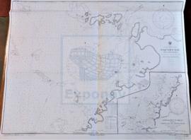
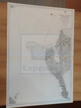
CARTA NÁUTICA

Taxonomy

Code

Scope note(s)

Source note(s)

Display note(s)

Hierarchical terms

CARTA NÁUTICA

Equivalent terms

CARTA NÁUTICA

Associated terms

CARTA NÁUTICA

324 Archival description results for CARTA NÁUTICA

324 results directly related Exclude narrower terms

SHETLAND ISLES

Zona Geográfica: Islas británicas
Islas Shetland (Mainland, Yell y Unst)

INSTITUTO HIDROGRÁFICO INGLATERRA

BLAKENEY TO FLAMBOROUGH HEAD

Zona Geográfica: Costa este de Inglaterra
Contiene las tierras de Yorkshire, Lincolnshire y Norfolk

INSTITUTO HIDROGRÁFICO INGLATERRA

GRAN BEREBI TO CAPE THREE POINTS

Zona Geográfica: Costa oeste de África
Contiene dos recuadros: Gran Berebi to Jack Jack con Sassandra anchorage y Jack Jack to cape Three Points con port Bouet

INSTITUTO HIDROGRÁFICO INGLATERRA

TEES BAY

Zona Geográfica: Costa este de Inglaterra
Aparece la bahía de Tees y el puente Victoria a la misma escala

INSTITUTO HIDROGRÁFICO INGLATERRA

BALTIC SEA

Zona Geográfica: Mar Báltico
Aparece el mar Báltico con la isla Gotland en el centro. Costas de Polonia, Lituania, Letonia, Estonia y Suecia.

INSTITUTO HIDROGRÁFICO ALEMANIA

BALTIC SEA

Zona Geográfica: Mar Báltico
Aparecen las costas de Noruega, Suecia y Dinamarca. Las tierras de Jutlandia. Isla de Fyen

INSTITUTO HIDROFRÁFICO NORUEGA

FAEROE ISLANDS TO NORWAY

Zona Geográfica: Atlántico norte
Aparece la costa de Noruega y las islas Feroe

INSTITUTO HIDROGRÁFICO INGLATERRA

FIRTH OF SOLWAY

Zona Geográfica: Costa oeste de Inglaterra
Aparecen las tierras de Cumberland, Dumfries y Kirkcudbright.

INSTITUTO HIDROGRÁFICO INGLATERRA

Results 211 to 220 of 324