- ES EXPONAV CARTAS NÁUTICAS CCN-000173
- Unidad documental simple
- 1916
Parte deCARTAS NÁUTICAS
Zona Geográfica: Costa sur de Noruega
Aparece la península Nessoden, Hurum landet.
Contiene un recuadro con Ide Fjord
INSTITUTO HIDROFRÁFICO NORUEGA
324 resultados directamente relacionados Excluir términos relacionados
Parte deCARTAS NÁUTICAS
Zona Geográfica: Costa sur de Noruega
Aparece la península Nessoden, Hurum landet.
Contiene un recuadro con Ide Fjord
INSTITUTO HIDROFRÁFICO NORUEGA
OUTER GABBARD TO OUTER DOWSING
Parte deCARTAS NÁUTICAS
Zona Geográfica: Costa este de Inglaterra
Contiene las tierras de Norfolk, Suffolk y Essex
INSTITUTO HIDROGRÁFICO INGLATERRA
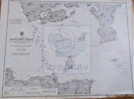
Parte deCARTAS NÁUTICAS
Zona Geográfica: Costa norte de Escocia
Tierras de la isla de Hoy, South Walls y South Ronaldsay. El estrecho de Outer y la isla de Stroma
INSTITUTO HIDROGRÁFICO INGLATERRA
PILOT CHART OF THE NORTH ATLANTIC OCEAN
Parte deCARTAS NÁUTICAS
Zona Geográfica: Océano Atlántico Norte
Carta de navegación del océano Atlántico
INSTITUTO HIDROGRÁFICO ESTADOS UNIDOS DE AMÉRICA
PLANO DE LA RADA Y PUERTO DE TARRAGONA
Parte deCARTAS NÁUTICAS
Zona Geográfica: Costa oriental España
Torre de la catedral de Tarragona, faro del Morro del dique de levante
INSTITUTO HIDROGRÁFICO ESPAÑA
PLANO DEL ARCHIPIÉLAGO DE CABO VERDE
Parte deCARTAS NÁUTICAS
Zona Geográfica: Océano Atlántico Norte
Plano de las diferentes islas que forman el archipiélago de Cabo Verde.
Contiene recuadros con los puertos de Praia y Preguiça.
INSTITUTO HIDROGRÁFICO INGLATERRA
PLANO DEL PUERTO Y ARSENAL DE CARTAGENA CON LA ENSENADA DE ESCOMBRERA Y LAS ALGAMECAS
Parte deCARTAS NÁUTICAS
Zona Geográfica: Costa SE de España
Plano del puerto y arsenal de Cartagena, islote de Escombrera
INSTITUTO HIDROGRÁFICO ESPAÑA
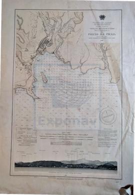
PLANO HIDROGRÁFICO DO PORTO DA PRAIA
Parte deCARTAS NÁUTICAS
Zona Geográfica: Costa Sul da Ilha de Santiago
Costas sur de la Isla de Santiago con la entrada del puerto da Praia y una vista panorámica levantada desde 1,1 millas al E. del faro de punta tenebrosa editada por el Ministerio de las Colonias.
INSTITUTO HIDROGRÁFICO PORTUGAL
PLANS EN THE ARQUIPÉLAGO DOS AÇORES
Parte deCARTAS NÁUTICAS
Zona Geográfica: Portugal. Océano Atlántico
Aparecen recuadros con la isla de Santa María, la bahía de San Lourenço y Vila do Porto
INSTITUTO HIDROGRÁFICO PORTUGAL
PLANS IN ARUBA, BANAIRE Y CURAÇAO ISLANDS
Parte deCARTAS NÁUTICAS
Zona Geográfica: Indias occidentales
Plano dividido en recuadros: Sta. Anna Baai and Schottegat (Curaçao) 1:8000 (1939); Reede Kralendijk (Bonaire) 1:50000 (1939); Bullen Baai (Curaçao) 1:10000 (1931); Caracas Baai and Spaansche Haven (Curaçao) 1:12500 (1929); St. Nicolaas Baai (Aruba) 1:15000 (1935); Paarden Baai (aruba) 1:15000 (1935); Fuik Baai 1:10000 (1938)
INSTITUTO HIDROGRÁFICO PAÍSES BAJOS