- ES EXPONAV CARTAS NÁUTICAS CCN-000071
- Item
- 1944
Part of CARTAS NÁUTICAS
Zona Geográfica: Océano Atlántico
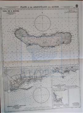
Recuadro con la isla de San Miguel
INSTITUTO HIDROGRÁFICO INGLATERRA
324 results directly related Exclude narrower terms
Part of CARTAS NÁUTICAS
Zona Geográfica: Océano Atlántico
Recuadro con la isla de San Miguel
INSTITUTO HIDROGRÁFICO INGLATERRA
Part of CARTAS NÁUTICAS
Zona Geográfica: Costa Sur de Inglaterra
Costa de Inglaterra desde Dodman hasta Start, con la ciudad de Plymouth y un recuadro con las rocas de Eddystone
INSTITUTO HIDROGRÁFICO INGLATERRA

Part of CARTAS NÁUTICAS
Zona Geográfica: Mar Mediterráneo
Visión del Mar Mediterráneo en la que están marcadas las zonas peligrosas y el Mar Negro.
INSTITUTO HIDROGRÁFICO INGLATERRA
APPROACHES TO THE BRISTOL CHANNEL
Part of CARTAS NÁUTICAS
Zona Geográfica: Costa Oeste de Inglaterra
Carta que representa los alrededores del canal de Bristol
INSTITUTO HIDROGRÁFICO INGLATERRA
CAPE BONIFATI TO STRAIT OF MESSINA
Part of CARTAS NÁUTICAS
Zona Geográfica: Costa Oeste de Italia. Mar Mediterráneo
Zona de Italia que va desde el cabo Bonifacio hasta el estrecho de Messina, que separa Calabria de Sicilia
INSTITUTO HIDROGRÁFICO INGLATERRA
Part of CARTAS NÁUTICAS
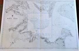
Zona Geográfica: Mar Báltico
Aparecen la bahía de Kiel y las tierras de Lolland, Holstein y la isla Fehmarn
INSTITUTO HIDROGRÁFICO ALEMANIA
MULL OF KINTYRE TO ARDNAMURCHAN
Part of CARTAS NÁUTICAS
Zona Geográfica: Costa Oeste de Escocia
Aparece la isla de Arran, la península de Kintyre y las tierras de Islay y Jura.
INSTITUTO HIDROGRÁFICO INGLATERRA
Part of CARTAS NÁUTICAS
Zona Geográfica: Mediterráneo
Isla de Creta. Contiene recuadros con Port Matala (escala 1: 9100), Sphakia (escala 1: 14560) y Anchorage
INSTITUTO HIDROGRÁFICO INGLATERRA
CALAIS TO THE R. SCHELDE ENTRANCE
Part of CARTAS NÁUTICAS
Zona Geográfica: Costa de Francia y Bélgica. Mar del Norte
Aparecen las costas de Francia, Bélgica y el paso de Calais.
INSTITUTO HIDROGRÁFICO FRANCIA
RIVER CLYDE. DUNOON TO PORT GLASGOW
Part of CARTAS NÁUTICAS
Zona Geográfica: Costa Oeste de Escocia
Aparecen las ciudades de Greenock, Helensburg, Dunoon y Kilcreggan. El lago Holy y el río Clyde
INSTITUTO HIDROGRÁFICO INGLATERRA